
- Yale Framework |
- Datasets |
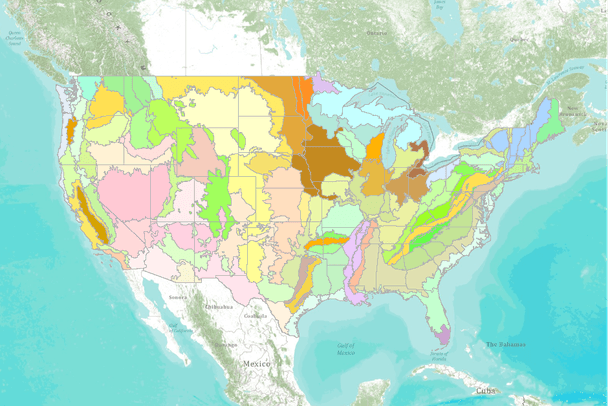
- United States EPA Ecoregions of the U.S. - Level III
United States EPA Ecoregions of the U.S. - Level III
May 13, 2010
(Last modified Jul 19, 2011)
Uploaded by
Conservation Biology Institute
Recommended by Tara Starr Marvin
- Description:
- Ecoregions denote areas of general similarity in ecosystems and in the type, quality, and quantity of environmental resources. They are designed to serve as a spatial framework for the research, assessment, management, and monitoring of ecosystems and ecosystem components.These general purpose regions are critical for structuring and implementing ecosystem management strategies across federal agencies, state agencies, and nongovernment organizations that are responsible for different types of resources within the same geographical areas. The approach used to compile this map is based on the premise that ecological regions can be identified through the analysis of patterns of biotic and abiotic phenomena, including geology, physiography, vegetation, climate, soils, land use, wildlife, and hydrology. The relative importance of each characteristic varies from one ecological region to another. A Roman numeral hierarchical scheme has been adopted for different levels for ecological regions. Level I is the coarsest level, dividing North America into 15 ecological regions. Level II divides the continent into 52 regions (Commission for Environmental Cooperation Working Group, 1997). At Level III, the continental United States contains 104 regions whereas the conterminous United States has 84 (U.S. Environmental Protection Agency, 2005). Level IV ecoregions are further subdivisions of Level III ecoregions. Methods used to define the ecoregions are explained in Omernik (1995, 2004), Omernik and others (2000), and Gallant and others (1989).
- Data Provided By:
- US Environmental Protection Agency
- Content date:
- not specified
- Citation:
-
Bryce, S.A., J.M. Omernik, and D.P. Larsen. 1999. Ecoregions - a geographic framework to guide risk characterization and ecosystem management: Environmental Practice 1(3):141-155.Commission for Environmental Cooperation. 1997. Ecological regions of North America: toward a common perspective. Commission for Environmental Cooperation, Montreal, Quebec, Canada. 71p. Map (scale 1:12,500,000). Revised 2006.Gallant, A.L., E.F. Binnian, J.M. Omernik, and M.B. Shasby. 1995. Ecoregions of Alaska. U.S. Geological Survey Professional Paper 1567. U.S. Government Printing Office, Washington D.C. 73p.Griffith, G.E., S.B. Bryce, J.M. Omernik, and A. Rogers. 2007. Ecoregions of Texas. Texas Commission on Environmental Quality. Austin, TX. 125p.Griffith, G.E., J.M. Omernik, C.M. Rohm, and S.M. Pierson. 1994. Florida regionalization project. EPA/600/Q-95/002. U.S. Environmental Protection Agency, Environmental Research Laboratory, Corvallis OR. 83p. 73 p.Griffith, G.E., J.M. Omernik, T.F. Wilton, and S.M. Pierson. 1994. Ecoregions and subregions of Iowa: A framework for water quality assessment and management. The Journal of the Iowa Academy of Science 101(1):5-13.McMahon, G., S.M. Gregonis, S.W. Waltman, J.M. Omernik, T.D. Thorson, J.A. Freeouf, A.H. Rorick, and J.E. Keys. 2001. Developing a spatial framework of common ecological regions for the conterminous United States. Environmental Management 28(3):293-316.Omernik, J.M. 1987. Ecoregions of the conterminous United States. Map (scale 1:7,500,000). Annals of the Association of American Geographers 77(1):118-125.Omernik, J.M. 1995. Ecoregions: A spatial framework for environmental management. In: Biological Assessment and Criteria: Tools for Water Resource Planning and Decision Making. Davis, W.S. and T.P. Simon (eds.), Lewis Publishers, Boca Raton, FL. p. 49-62.Omernik, J.M., S.S. Chapman, R.A. Lillie, and R.T. Dumke. 2000. Ecoregions of Wisconsin. Transactions of the Wisconsin Acadamy of Sciences, Arts, and Letters 88:77-103.Omernik, J.M. 2004. Perspectives on the nature and definition of ecological regions. Environmental Management 34(Supplement 1):S27-S38.Wiken, E. 1986. Terrestrial ecozones of Canada. Environment Canada. Ecological Land Classification Series No. 19. Ottawa, Canada.
- Contact Organization:
-
U.S. Environmental Protection Agency, Office of Research & Development (ORD) - National Health and Environmental Effects Research Laboratory (NHEERL)Comments and questions regarding the Level III and IV Ecoregions should be addressed to Glenn Griffith, USGS, c/o US EPA., 200 SW 35th Street, Corvallis, OR 97333, (541)-754-4465, email:griffith.glenn@epa.gov Alternate: James Omernik, USGS, c/o US EPA, 200 SW 35th Street, Corvallis, OR 97333, (541)-754-4458, email:omernik.james@epa.gov
- Contact Person(s):
- Use Constraints:
 This work is licensed under a Creative Commons Attribution 3.0 License.
- Layer:
- Layer Type:
- Currently Visible Layer:
- All Layer Options:
- Layers in this dataset are based on combinations of the following options. You may choose from these options to select a specific layer on the map page.
- Description:
- Spatial Resolution:
- Credits:
- Citation:
- Purpose:
- Methods:
- References:
- Other Information:
- Time Period:
- Layer Accuracy:
- Attribute Accuracy:
FGDC Standard Metadata XML
Click here to see the full FGDC XML file that was created in Data Basin for this layer.
Original Metadata XML
Click here to see the full XML file that was originally uploaded with this layer.
This dataset is visible to everyone
- Dataset Type:
-
Layer Package
Downloaded by
49 Members
Bookmarked by
9 Members
,
7 Groups
Included in
14 Public Maps
,
34 Private Maps
Included in
6 Public Galleries
About the Uploader
Conservation Biology Institute
We provide advanced conservation science, technology, and planning to empower our partners in solving the world’s critical ecological challenges