
Future climate change will cause species to shift their distributions across, likely forming new communities and ecosystems. Until recently, conservation planning has largely focused on identifying areas that protect current patterns of biodiversity. Although these areas may provide protection for today’s biodiversity, they may not provide adequate protection for biodiversity in a future world that looks very different from that of today.
One potentially promising strategy for protecting biodiversity in a changing climate is to protect the diversity of the geophysical landscape that influences patterns of biodiversity. Species distributions, communities, ecosystems, and broader patterns of biodiversity are influenced by landscape characteristics such as soils, geology, topography, and climate. Although climates will change relatively rapidly over the coming century, soils, geology, and topography will not. By protecting a diversity of geophysical landscape components (referred to here as land facets), it may be possible to protect areas that will foster a diversity of biota in the future —albeit different biota than those areas harbor today.
Although the idea of using landscape diversity as a proxy for biodiversity is not new, it has only recently been applied to address conservation problems under a changing climate. Thus, the method has not been tested on a wide diversity of landscapes, nor do we know how well currently protected areas already protect land facets. Here we address these questions by identifying and mapping land facets across three ecoregions in the Pacific Northwestern United States. We describe the sensitivity of the facets to methodological and data choices, evaluate how well land facets are represented in current protected areas, use these land facets to prioritize areas for conservation, and evaluate how well these conservation areas can capture current biodiversity. The final step in the project (currently underway) is to use the answers to the various questions listed above to select one or more approaches to defining facets use that approach to generate land facets for 14 ecoregions across the Pacific Northwest.
Objectives
- Test the sensitivity of land-facet delineation to: a) the method used, b) the variables used, c) the spatial resolution of the data used, and d) how the data are normalized.
- Assess the degree to which the land can act as a surrogate for current patterns of biodiversity.
- Determine how well land facets are represented in current protected areas and current conservation priority areas.
- Using the most applicable land-facet approach, define facets for 14 ecoregions in the Pacific Northwest.
Geographic Location
Pacific Northwestern United States
Principal Investigator
Joshua Lawler
Ecosystem Type
Terrestrial
Framework focus
Study sites
We chose three ecoregions with varying areas, ranges of elevations, and vegetation types—the Willamette Valley, East Cascades, and the Columbia Plateau. These are three of fourteen ecoregions to which the most applicable analyses will be extended (Study Region). The Willamette Valley is a 1.48 million hectare area bounded by the Cascade Mountains to the east, the Oregon Coastal Mountains to the west, and the Klamath Mountains to the south. The landscape is composed of terraces and floodplains of the Willamette River, buttes,and hills. Much of the ecoregion is at relatively low elevation and is flat.Before the ecoregion was heavily altered by agriculture and urbanization, it largely contained prairies, oak savanna, coniferous forests, wetlands, and riparian forest. The East Cascades ecoregion is a 6.78 million hectare ecoregion in the eastern rainshadow of the Cascade Mountains. It is characterized by frequent fires and is dominated by open forests of ponderosa and lodgepole pine.The Columbia Plateau ecoregion is a 29.7 million hectare area bounded by the Rocky Mountains to the east and the Cascade Mountains to the west. The landscape is composed the Columbia and Snake River drainages, broad plateaus, steep basalt coulees, pothole lakes and vernal pools. The Columbia plateau is relatively dry, is dominated by sagebrush steppe, and has been heavily altered by human use.
Study Region: Map shows 14 Pacific Northwest ecoregions with the 3 ecoregions used for sensitivity analyses highlighted in color: Willamette Valley (red), East Cascades (blue), and Columbia Plateau (purple).

Variable choice
We examined the role of variable choice in land-facet classification and subsequent prioritization of conservation areas by comparing facets defined with different combinations of topographic variables (elevation and slope), soils (organic matter, bulk density, depth to bedrock, depth to the root restrictive layer, accumulated water content) and geology (classified into nine different groups).
Resolution
We analyzed the effect of the resolution of the data on facet definition by using two resolutions of raster data: 270m and 1km.
Data normalization
We normalized the data used in the clustering algorithms and tested the influence of normalizing data within an ecoregion versus normalizing data across all 14 ecoregions.
Facet designation
We analyzed three different approaches for designating facets:
- Categorical overlay- in which each variable is categorized into ecologically meaningful classes. Land facets are created from unique combinations of those classes.
- K-means clustering- is an algorithm that clusters the continuous variables into a designated number of facets. The Hartigan index was used to identify the optimal number of facets.
- Hybrid approach- combines the categorical overlay and a clustering method. Topographic data were categorized, and within each topographic class, all other variables were clustered using a fuzzy c-means algorithm
Across the three ecoregions, the number of facets identified within each facet model (i.e., each combination of variables, approaches, and resolutions) ranged from as few as six facets to as many as 4,589 facets.
Prioritization
For each facet model, we used the program Marxan to prioritize planning units (hydrological unit codes, HUCs) for conservation. We aimed to represent, in a network of planning units, 30% of the land covered by each of the facets in a given ecoregion. We used a measure of land suitability as the cost of each planning unit based on four premises: land in a given planning is more suitable (and less costly) for conservation if it 1) less fragmented, 2) occurs in large patches, 3) consist of habitat areas that are closer together, and 4) is publicly owned and managed.
Model sensitivity
We compared the spatial distributions of prioritized planning units under different models. Specifically, we compared how often a planning unit was chosen in 1,000 iterations, or the irreplaceability value, between facet models. A planning unit that is highly irreplaceable is prioritized in most or all of the 1,000 Marxan iterations whereas a planning unit with low irreplaceability is prioritized in few or no iterations.
Ability of facet-based conservation areas to protect current biodiversity
NatureServe (Natureserve 2012) defines ecological systems as “biological communities that occur in similar physical environments and are influenced by similar dynamic ecological processes, such as fire or flooding.” We used ecological system diversity (see www.natureserve.org) as a proxy for biodiversity. Thus, to assess how well facet-based conservation areas protect current biodiversity, we evaluated how efficiently ecological systems are represented as planning units are prioritized to conserve land facets. Inversely, we also used ecological system types to prioritize planning units in Marxan, and then assessed the rate of accumulation of facet types.
We assessed the representation of land facets in protected areas and current conservation plans by evaluating the percentage of targets represented in protected areas with GAP status 1 or 2 and in TNC portfolio sites.
Additional Details Regarding Methods
Results
Different approaches to defining facets produced different maps of land facets (Fig. 2). Not surprisingly these often resulted in areas being prioritized differently for conservation.
Nonetheless, some planning units were always identified as priorities (i.e.,
they were highly irreplaceable) regardless of facet model. Conservation prioritization was more sensitive to some methodological decisions than others (Fig. 3a). Decisions regarding data normalization and resolution had very little influence on the distribution of conservation priorities, variable choices had more of an influence, and the approach for designating facets had the most influence on prioritization (Fig. 3a). In general, prioritization within the Willamette Valley and the Columbia Plateau were less sensitive to methodological decisions than was the East Cascades (Fig. 3b).
Figure 2. Land facets. Unique land facets mapped for each facet model type defined for the Willamette Valley.
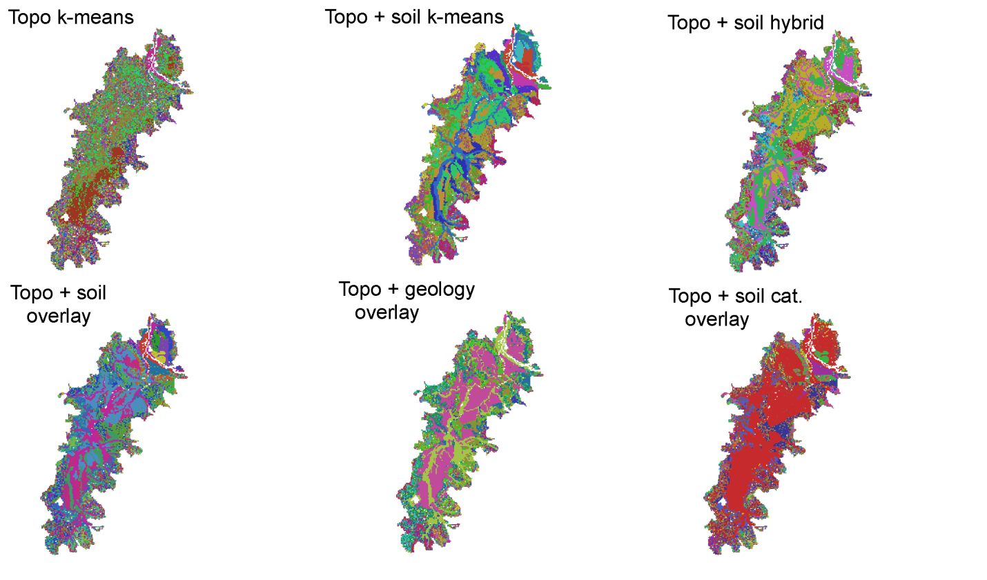
Figure 3 . Similarity of conservation priorities between facet models. Boxplots compare the correlation coefficients of irreplaceability values between different facet models for a) all three ecoregions together and b) facet models within each ecoregion. Boxes represent the interquartile range, the bold line represents the mean, and the whiskers extend to the most extreme value within 1.5 times the interquartile range. Circles are values more extreme than 1.5 times the interquartile range.

The efficiency with which ecological systems were represented was similar in the three ecoregions (Fig. 4). To represent 80% of ecological systems, approximately 40% of planning units must be protected (Fig. 4). Current protected areas in all three ecoregions fail to represent over half of the ecological systems and land facets at target levels of 30% (Fig. 5). Protected areas are generally better at representing the diversity of ecological systems than they are at representing the diversity of land facets. Protected areas poorly represent the diversity of the Willamette Valley because only 1% of this ecoregion is protected whereas 10% of the land area of the East Cascades and the Columbia Plateau are protected. Proposed conservation areas better represent both ecological systems and land facets than do current protected areas in all of the ecoregions (Fig. 5). Regardless, less than half of the land facet diversity is represented at 30% target levels in priority conservation areas in the Columbia Plateau and the Willamette Valley. The proposed conservation areas in the East Cascades cover 45.5% of the ecoregion’s land area, and therefore, adequately represent the diversity of the facets in the ecoregion. Proposed conservation areas in the Willamette Valley and the Columbia Plateau cover only 25.6% and 23.3% of each ecoregion respectively.
Figure 4. Cumulative representation of Ecological Systems. The accumulation of ecological systems with at least 30% of their area represented in planning units (HUCs) selected in order of decreasing irreplaceability of the HUCs for representing facets. Solid lines are means and dashed lines are standard deviations for each ecoregion based upon all facet models.

Figure 5. Facet Representation. The percentage of facets (solid line) and ecological systems (dotted line) represented at every targeted quantity between 0.5% of the total area of each facet or ecological system and 50% of the total area of each facet or ecological system by increments of 0.5% for a) current protected areas and b) current conservation plans.

Using land facets to prioritize areas for conservation in the face of climate change eliminates the uncertainty of planning for climate change based on uncertain future climate-change models and projected shifts in species distributions.
However the method is not without its challenges. Methodological decisions made in the process defining facets can greatly affect the prioritization of planning units (Fig. 2a). Additionally, the relative comparability of different models across ecoregions varies. In the East Cascades—the area of highest landscape variation— methodological choices affected conservation planning more than in the other two ecoregions (Fig. 2b). As a result, care should be taken to select the appropriate modeling method depending upon the overall landscape variation in the region being modeled. It may be important to compare several facet models to determine the best model for the landscape of interest or at least to understand the impact of these decisions on conservation priorities.
Figure 2. Land facets. Unique land facets mapped for each facet model type defined for the Willamette Valley.
The efficiency with which planning units prioritized to represent facets also represent ecological systems was somewhat similar across facet models (Fig. 3). However that efficiency was relatively low, indicating that prioritization of conservation regions using facets alone will not efficiently provide protection for current biodiversity. Lastly, the ability of both protected areas and portfolio sites to include land-facet diversity seems directly correlated with overall land area covered by those sites. The fact that protected areas and proposed conservation areas do not always capture land-facet diversity (Fig. 4) indicates that including land facets as a goal will complement, rather than replace current methods for selecting protected areas.
Figure 3 . Similarity of conservation priorities between facet models. Boxplots compare the correlation coefficients of irreplaceability values between different facet models for a) all three ecoregions together and b) facet models within each ecoregion. Boxes represent the interquartile range, the bold line represents the mean, and the whiskers extend to the most extreme value within 1.5 times the interquartile range. Circles are values more extreme than 1.5 times the interquartile range.
Figure 4. Cumulative representation of Ecological Systems. The accumulation of ecological systems with at least 30% of their area represented in planning units (HUCs) selected in order of decreasing irreplaceability of the HUCs for representing facets. Solid lines are means and dashed lines are standard deviations for each ecoregion based upon all facet models.